Finding the American Flyer Chicago Factory Locations
By Leon Sweet
Collecting American Flyer Prewar trains and living in Chicago, I had always thought about driving by the 3 American Flyer former factory locations and taking photos. My profession as a commercial real estate appraiser also peaked my interest in seeing the former locations. In fact in the late 1990s, I had driven by the 2229 South Halsted Street factory where American Flyer was located from 1914/1915 until their sale to AC Gilbert in 1938. I also knew the general location of the 1910-1920 Kinzie Street facility, where Flyer was located from 1909 to 1914. I guessed that the location of the 1088 Wilcox Avenue property, Flyer’s initial location from 1907 to 1909, would also be easy to find. I would later discover that finding the 1088 Wilcox Avenue location would not be as easy as I thought.
My quest for finding the properties was further spurred on by an invite I extended to a fellow Prewar American Flyer collector, Hollis Cotton. He indicated an interest in seeing the South Halsted Street factory and I said, “why not all three locations?”
In preparation for his visit, I researched the properties using mapping software, the Cook County Assessor’s website, and approximate 10-year old copies of Sanborn Fire Insurance Maps for Chicago.
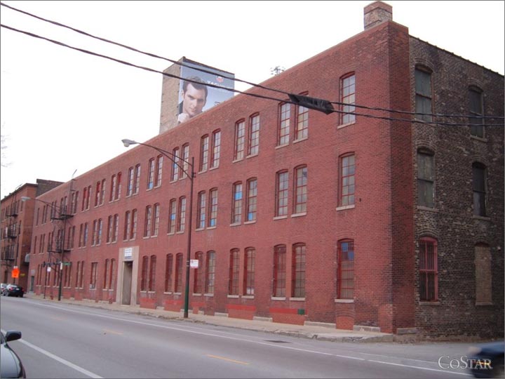
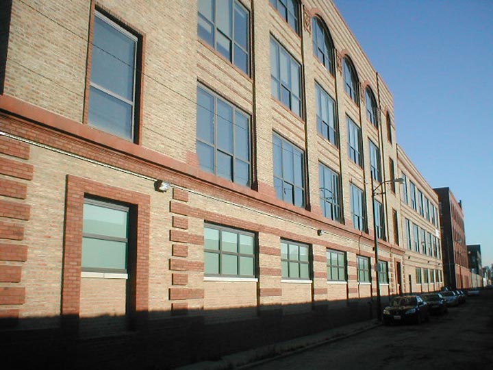
The Halsted Street factory was easy to find and the Cook County Assessor’s office lists the building address as 2229 South Halsted Street. According to the Assessor, the building was constructed in approximately 1903. The rear of the building abuts to the Dan Ryan Expressway (I-90) and the building is just to the south of Cermak Road. It is my understanding that the building originally comprised 7-stories, but presently only the first 3 floors and a 7-story elevator shaft remain due to a large fire in 1951, which destroyed the upper floors (per Si Chaplin’s comments in the American Flyer Collector’s Club – Collector). Additionally, I recall reading that there was formerly a barge dock/slip behind the property, which apparently was filled in when the Dan Ryan Expressway was constructed. It was interesting for me to note that the exposed portion of the building’s 7-story elevator shaft is currently a premium 3-sided advertising billboard along the Dan Ryan Expressway, which likely generates as much or more income than the remainder of the building. The neighborhood surrounding this property is still an industrial neighborhood.
The Kinzie Street building was also easy to find and the Cook County Assessor’s office lists the building address as 1910 West Kinzie Street. According to the Assessor, the building was constructed in approximately 1902. The building is described as a loft constructed industrial building and is at the northeast corner of Kinzie Street and Hart Avenue. Again, the neighborhood surrounding this property is also still an industrial neighborhood.
One thing I noted immediately is that the advertisement that announces the factory moving to this location prominently indicates that the building is “Between Lincoln and Robey Streets”. That statement struck me as odd, as the main streets to the east and west of the property are Wolcott on the east and Damen Avenue on the west. Further research led me to discover that Damen Avenue was originally called Robey Street and Wolcott Avenue was originally known as Lincoln Street (and still is known as Lincoln Street for a couple of blocks on Chicago’s far south side.
I also thought it was odd that an advertisement should note that the property was “Between Lincoln and Robey Streets” but initially overlooked the significance of that statement. In hindsight I see that it was the clue that I needed to discover the location of 1088 Wilcox Avenue.
My search for Wilcox Avenue led me to Wilcox Street, which runs in an east-west direction between Monroe and Adams Streets. However, Wilcox Street does not start until approximately 2300 West Wilcox. Knowing that the Wilcox Avenue facility was destroyed by fire, I thought maybe the street had been vacated to allow construction of a larger facility after the fire. I searched the tax maps for the 1000 block of Adams and Monroe Streets, but could not find the appearance of a vacated street in this vicinity. I Googled “Chicago street maps for the 1890s”, thinking that maybe I could get an idea of the property’s location that way. That initially appeared to be a dead end also, as Wilcox Avenue did not exist on these maps in the vicinity of the 1000 block of West Adams or Monroe Streets. The maps from the 1890s showed Wilcox Avenue in its present day location and no real extensions to the east. I thought maybe Wilcox Avenue had been renamed like Robey and Lincoln Streets. I Googled and found an historic street listing that was written in 1948 that listed Chicago street names and any previous names. This too appeared to be a dead end.
Finally I found a map that showed the new street numbering system that went into effect on September 1, 1909. Now the statement in the announcement of the American Flyer factory moving from Wilcox to Kinzie Streets that specifically stated “Between Lincoln and Robey Streets” made sense. They would want to highlight the cross streets due to the new numbering system, because it would allow people to find the new address number easier. With the entire city being renumbered in 1909, I guessed that the 1088 Wilcox Avenue address must have been the former address for the building. I guess one could say “I missed by a mile” in my estimate of where the building should have been, based on the current numbering system.
Instead of the property being in the vicinity of the 1000 block of present day Adams and Monroe Streets it was actually in the vicinity of the 2400 block of the present day street, where Wilcox Street still exists and existed in 1907-1909. A list that compares the Old Street Numbers to the New Street Numbers, indicated that 1088 Wilcox became 2609 Wilcox as mandated by the city of Chicago on September 1, 1909.
The Cook County Assessor’s website shows this address as being a vacant parcel of land on the southeast corner of Wilcox Street and the Rockwell Street railroad corridor, 2-blocks to the west of Western Avenue. The property is listed as being tax exempt, so it is likely owned by the city of Chicago or some other tax exempt entity. The parcel appears to be in an older residential neighborhood that was dominated by the Rockwell Gardens public housing complex which was is on both sides of Wilcox Street, between Rockwell Street and Western Avenue until approximately 4 years ago, when the complex was demolished. Rockwell Gardens was constructed in 1961 and was demolished in 2006 and is currently vacant land that is slated for redevelopment with 750 units of public housing. The immediate neighborhood appears to be 1 to 3 flat buildings to the north, south, and west of the property, with the immediate surrounding sites also being vacant land.